In this post, MVC Organising Committee member Yolande Stone provides an extensive professional analysis of the planning considerations which must be taken into account should Woolworths seek approval for a large supermarket development in Mosman village.
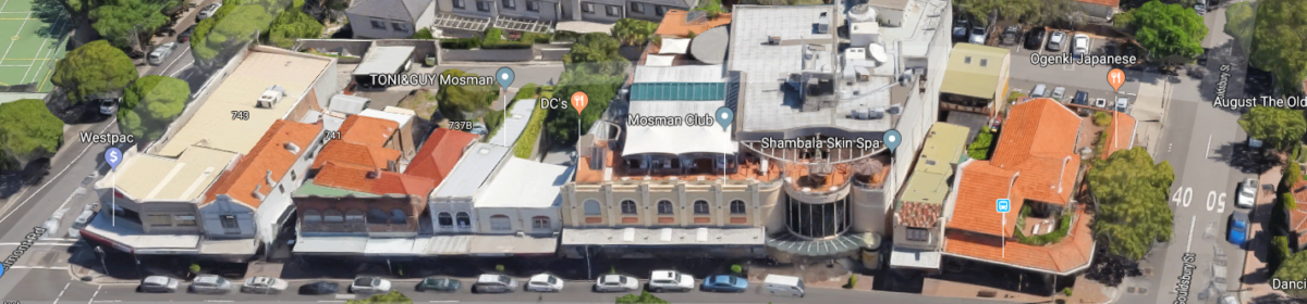
Site : 713-743 Military Road and rear road access
Zoning
B2 Local Centre
Permitted Uses
Range of commercial uses including:
- Car parks
- Commercial premises (including office, business and retail)
- Entertainment facilities
- Function centres
- Registered clubs
- Residential flat buildings
Height Limits
11 metres (Area L)
Floor Space Ratio Limits
2 : 1
Heritage
Heritage Conservation Area with the following Military Road lots considered to be contributing to the ranking:
- Contributory – 1
- 717: Flight Centre
- 735: Tony and Guy
- 740: Pasta Zu
- Contributory – 2
- 737: Eco d
- 739: Mosman Noodle Bar
It should be noted that the following are considered to be “Detracting” from the Heritage Conservation Area:
- Detracting
- 713: Bonza Kids
- 719: Mosman Club
- 743: Wespac & Harvey
See Appendix 2 below for details of Heritage Rankings.
Site : 40 Gouldsbury Road
Zoning
R3 Medium Density Residential
Permitted Uses
- Range of residential uses are permitted including
- Residential flat buildings
- Commercial premises are not permitted, such as
- Entertainment facilities
- Function centres
- Registered clubs
Height Limits
8.5 metres
Floor Space Ratio Limits
0.7 : 1
Heritage
Heritage Conservation item of “General” significance.
Lot 40 is listed as Item I108 along with the 3 adjoining houses.
Comments
Zoning
The Military Road sites including the Mosman Club (occupying 719 which consolidates lots 719-729) is not likely to raise any planning issues with regard to permitted land uses.
However the Gouldsbury Road site would be restricted to residential uses only and would require a zoning change if non-residential uses are proposed.
Heights
Clause 4.3 of the LEP prescribes a height limit of 11 metres (Area L) for the Military Rd sites – usually 3 stories (not counting any basement).
It is noted that in Area O from 742 Military Road to Spit Junction height limits are 15 metres. In addition, 748 Military Rd (old building where Country Road is located) has a specific height limit of 12.6 metres.
Height limits can be varied using Clause 4.6 of the LEP which provides a process which is used often in Mosman.
Floor Space Ratio (FSR)
Clause 4.4 of the LEP prescribes FSR of 2:1 for the Mosman Junction area along Military Road zoned B2.
It should be noted that the B2 zoned area from 645 Military Road (Jigsaw) to around Spit Junction has a FSR of 2.5:1 while the Medium Density R3 residential zone along Military Road opposite the site has a FSR of 1:1.
Medium Density R3 Residential Zone along Gouldsbury Road only has a FSR of 0.7:1.
FSRs can be varied using Clause 4.6 of the LEP which provides a process which is used often in Mosman.
Heritage Conservation Area
Mosman Junction B2 zone has been identified as a Heritage Conservation Area.
The clause 5:10 of the LEP requires that the consent authority must, before granting consent in respect of a heritage item or heritage conservation area, consider the effect of the proposed development on the heritage significance of the area concerned.
In addition, the provisions of the Mosman DCP on Heritage Conservation for the Mosman Junction Business Centre require that any development in the conservation area must:
(a) Maintain the Military Road heritage streetscape as Australia’s most significant Federation streetscape.
(b) The ranking of the building within the conservation area must be considered and guide any works.
See Appendix 1 for more details.
Process for varying development standards – Clause 4.6
Development consent may be granted to development that contravenes a development standard in the LEP if the consent authority:
(a) has received a written request from the applicant that justifies the contravention of the development standard by demonstrating that compliance with the development standard is unreasonable or unnecessary in the circumstances of the case, and that there are sufficient environmental planning grounds to justify contravening the development standard.
(b) considers the proposed development will be in the public interest because it is consistent with the objectives of the particular standard and the objectives for development within the zone in which the development is proposed to be carried out, and
(c) has received the concurrence of the Secretary of the Dept of Planning – after considering whether contravention of the development standard raises any matter of significance for State or regional environmental planning or if any public benefit of maintaining the development standard would be undermined.
Who determines the DA
The Minister for Planning or Planning Commission would not have a role in determining the DA unless the site is declared to be a State Significant Site or the development State Significant Development, which is highly unlikely.
Otherwise there are three options:
1. Sydney North Planning Panel (SNPP)
Three members are appointed by the Minister and two by Mosman Council.
If the development is valued at more than $30M, the DA will be assessed by Mosman Council Officers, with recommendations made to the SNPP. The SNPP considers the report, may seek additional advice and hold a public hearing. They then make a determination.
The applicant can also refer DA’s valued between $10M-30M to the SNPP for determination, if the DA has not been determined within 120 days.
2. Mosman Local Planning Panel (MLPP)
Members are appointed by Mosman Council.
DAs are referred to MLPP if
- there are more than 10 “unique” submissions opposing the development or
- the DA proposes a variation on development standards by more than 10% (such as height or FSR) or other qualitative standards.
The DA is assessed by Mosman Council Officers, with recommendations to the MLPP. The MLPP considers the report, may seek addition advice and holds a public hearing. They then make a determination.
3. Mosman Council Officers
DA’s not meeting the above criteria are assessed and determined by Mosman Council Officers. Councillors do not have a formal role.
Appendix 1
Business Centres Development Control Plan 2012
Development Control Plans (DCPs) are plans adopted by Council to support the Mosman Local Environmental Plan 2012 and provide more detailed planning and design guidelines. The relevant DCP should be referred to when considering development.
Mosman Junction Business Centres
DESCRIPTION OF AREA AND CHARACTER
The Mosman Junction business centre is a key retail centre in Mosman, containing over 150 shops which generally serve local shopping needs, but also includes some high quality, boutique style shops and cafes, restaurants and a pub. The centre is focused along a traditional strip shopping centre, over 400 metres in length, and spills into some of the side streets and through arcades to public car parking areas. The main street has a consistent and well defined streetscape character comprising Federation and Inter-War traditional terrace shopfronts which creates a pleasant atmosphere and experience for the shopper.
The Military Road Conservation Area covers the Mosman Junction business centre. Buildings are generally consistent in form, age and height, with predominantly a 2 storey street wall height. Traffic and pedestrians seek to share the street and sometimes there is conflict. The historic significance of Military Road is that it formed part of the earliest residential and military development of Mosman. It is associated with the area as a major defence post in Sydney Harbour. The road influenced the growth of the suburb because it was, and still is, the major traffic route to and from the area. It became the centre of retail and commercial activity in the suburb.
In aesthetic terms, the commercial and retail area of Military Road is a marvellous microcosm of the range of architecture to be found in Mosman, distinctively combining retail and residential uses in a unified, lively and diverse linear and curvilinear streetscape. Its scale is pleasantly moderate and the variety of forms, materials, textures and colours is full of interest. The successful integration of some facades of later and very recent vintage, indicates that good design is an ageless quality.
The ‘village’ atmosphere prevails despite some unhappy incursions. Several impressive buildings elevate the generally good aesthetic quality of the Conservation Area to a high level of value. The social significance of the area lies first in the fact that here can be seen a great many of Mosman’s municipal, commercial and principal educational institutions, as well as stretches of residential development. It is associated with prominent developers who erected speculative ensembles of shops, dwellings and commercial occupancies, and with the sequences of tenants in retail, trade and commerce activities, many of them well-known, identifies past and present in Mosman. (Source: Mosman Heritage Review, 1996, prepared by Godden Mackay Heritage Consultants)
PLANNING CONTROLS
Mosman Junction Business Centre Heritage conservation
(a) Maintain the Military Road heritage streetscape as Australia’s most significant Federation streetscape.
(b) The ranking of the building within the conservation area must be considered and guide any works.
Activities and land use mix
(c) Encourage a viable and vibrant mixed use centre of regional significance that provides a diversity of retail, commercial, community, residential and other uses. Retail and other active uses are to be at street level, with residential/commercial uses above. Businesses and services are to remain accessible to the community.
Building form and design
(d) Encourage development that is compatible with the existing 2 storey Federation streetscape, and the existing scale and rhythm of development. The amenity of the centre is found in the scale, form styles, material and details in the streetscape.
(e) Encourage alterations and additions to be located to the rear of the building and respect the scale, form, proportion of the host building. Infill development should respond and contribute to the existing character of the streetscape.
(f) Encourage awnings and façade colours of a common Federation colour for groups of buildings forming a terrace.
Streetscape, amenity and access
(g) Extend the network of shopfront promenades, laneways and through-site arcades to improve pedestrian accessibility, safety and amenity. This includes:
- through-site arcades between Military Road and rear lanes/carparks;
- lane widening in Lennon Lane, Martens Lane, Post Office Lane, and Ritchie Lane;
- other opportunities for improved pedestrian circulation through the centre.
(h) Avoid vehicular access to properties from Military Road. Provide vehicular access to properties from secondary roads and rear lanes.
(i) Encourage improved streetscape amenity by locating power lines underground for new development in Bradleys Head Road, Middle Head Road and Raglan Street. Maintain and enhance individual items and the heritage streetscape Awnings and facade colours should be a common Federation colour for groups of buildings forming a terrace.
Appendix 2
Heritage Conservation Area (HCA) Rankings
Under Mosman Business Centres Development Control Plan 2012 – amended JUNE 2018 – the statement of heritage significance, and ranking of the building within the conservation area, must be considered and guide any works.
A map showing the ranking of buildings in conservation areas is available to be viewed on Council’s website (www.mosman.nsw.gov.au/planning/heritage).
Description Objectives of development control
Ranking : Heritage item
Description
Buildings individually listed as a heritage item in Mosman LEP 2012.
Objectives of development control
Maintain the heritage significance of the item.
Ranking : Contributory 1
Description
Buildings that clearly reflect a Key Period of Significance for the HCA and are key elements of the HCA.
This ranking was assigned where the main front portion of the building is largely unaltered as viewed from the street. Includes houses with rear additions which do not affect the main front roof.
Objectives of development control
Maintain heritage characteristics and streetscape intactness.
Ranking : Contributory 2
Description
Buildings that have been altered but are still identifiable as dating from a Key Period of Significance for the HCA. They retain their overall form from the original date of construction and, even though altered, are contributory to the HCA character.
This ranking was assigned where a building has alterations such as cement rendering to Federation or Inter-war period brickwork or a first floor addition which affects the main front roof form, but the period and style of the house remains discernible.
Objectives of development control
Reconstruct original features by removing unsympathetic additions or using more appropriate decorative treatment.
RANKING : Neutral
Description
Buildings that are either heavily altered to an extent where the construction period is uncertain, or are from a construction period which falls outside any Key Period of Significance for the HCA, but which reflect the predominant scale and form of other buildings within the HCA, and therefore do not detract from the character of the HCA.
This ranking was assigned where the building is either so altered the period and style is no longer evident, or it is a recent building which is of a height, form and scale which is consistent with the streetscape.
Objectives of development control
Maintain benign affect.
RANKING : Detracting
Description
Buildings from a construction period which falls outside any Key Period of Significance for the HCA and that have scale or form that is not consistent with the key characteristics of the area.
This ranking was assigned where the building is recent/late 20th century and is out of scale, not consistent with the height, form and scale of buildings within the streetscape.
Objectives of development control
Encourage the ultimate replacement of the building with one less assertive, or amelioration of its adverse impact by sympathetic alterations, plantings, more appropriate colour scheme or other treatment.
Fabulous document, Yolande. It spells out in language that the planning bureaucrats know and understand!
It is very clear to me that there is no justification, in terms of local planning, for permitting this over-sized development at 713-743 Military Road and the rear road access.